Will the winds in many parts of the country cool down this winter and really "freeze and cry"?
BEIJING, Beijing, September 27 (Ma Xueling, Lu Chunrong) On the 27th, there was strong wind and cool weather in Beijing. With the cold air heading south, the temperature in most parts of central and eastern China will generally drop in the next few days, which also makes the hot topic of "Crying in the Winter" once again appear on the Internet. So, will you really cry this winter?
Beijing gale cooling: it is estimated that the minimum temperature of level 7 gust is 12℃
This morning, there was a strong wind in Beijing, which made me feel cold.
China Weather Network reported that due to the influence of cold air, the northern wind began to take over the sky of Beijing at 4 or 5 o’clock this morning. According to meteorological monitoring, as of 5: 30 this morning, gusts of magnitude 6 or above have appeared in Haidian Station, Chedaogou, Xiangshan, Bei ‘an River, Fenghuangling, yongfeng middle school and Minzhuang.
The Beijing Meteorological Observatory issued a weather forecast at 6 o’clock today: it will be cloudy and sunny during the day, with a northerly wind of about five and a gust of about seven, with a maximum temperature of 23 C; It’s sunny at night, and the north wind turns from level 4 to level 23, with a minimum temperature of 12℃. In the gale blue warning, pay attention to wind protection and prevent falling objects.
At 17: 00 the day before, the Beijing Meteorological Observatory issued a blue warning signal for strong winds. It is estimated that there will be northerly winds of Grade 4 and 5 from north to south in Beijing from 4: 00 to 20: 00 on the 27th, and the gust can reach about Grade 7.
Cold air goes south in a big way, and autumn tigers turn into paper tigers in seconds.
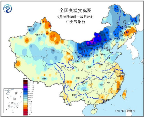
In addition to Beijing, this morning, most parts of Inner Mongolia also experienced significant cooling, with the cooling rate in some areas exceeding 10℃ and the temperature falling below 5℃.
According to the news released by the Central Meteorological Observatory this morning, it is estimated that the temperature in most parts of central and eastern China will drop by 4 ~ 6℃ from north to south from September 27th to 29th due to the influence of cold air, with the temperature drop in the south-south area of eastern Inner Mongolia and the south-central part of northeast China reaching 8 ~ 10℃. There are 5 ~ 6 winds in parts of central and eastern Inner Mongolia, southern Northeast China, eastern North China and eastern Huanghuai.
Under the influence of cold air, the highest temperature in southeastern and northeastern Inner Mongolia generally dropped to around 15℃, and in some areas it was only around 10℃. On the 28th, the lowest temperature in eastern Inner Mongolia and Heilongjiang will drop to around 0℃. The highest temperature in North China has generally dropped by 20℃ in the early days, and autumn is getting stronger.
With cold air heading south and typhoon Miyu landing, the temperature in the south of the Yangtze River and South China will drop rapidly from 28th, and the highest temperature in most parts of the south of the Yangtze River and Guangdong will drop below 30℃. The hot weather will fade rapidly, and the autumn tiger will turn into a paper tiger.
Will you cry this winter?
For this windy and cool weather, some netizens said, "An autumn rain and a cold, in fact, it is nothing to cool down now. This winter, we may be frozen into dogs."
The reason why netizens have the above concerns is because of a word recently swiped — — La Nina.
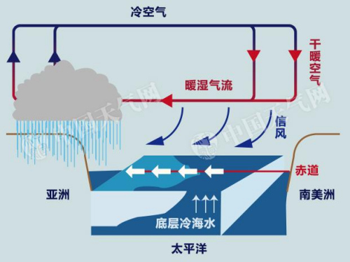
The word "LaNina" comes from Spanish, originally meaning "little girl", which refers to the phenomenon that the sea surface temperature in the equatorial, Middle East and Pacific Ocean continues to be abnormally cold. If the 3-month moving average of SST anomaly is lower than -0.5℃ and lasts for at least 5 months, it is judged as a La Nina event.
Monitoring shows that in August 2016, the SST anomaly index in the equatorial Middle East Pacific was -0.53℃. According to the National Climate Center of China Meteorological Bureau, the equatorial Middle East Pacific entered La Nina state in August.
Li Xiaoquan, chief meteorologist of China Weather Network, said in an interview with Zhongxin. com (WeChat WeChat official account: cns2012) that it is still early in winter, and the authoritative meteorological department has not given the final forecast figures. It is still inconclusive whether La Nina will occur this winter.
"But now that we have entered the La Ni? a state, La Ni? a events may occur this winter. According to relevant analysis, in general, the probability of being cold this winter is greater." Li Xiaoquan said.
How powerful is La Nina?
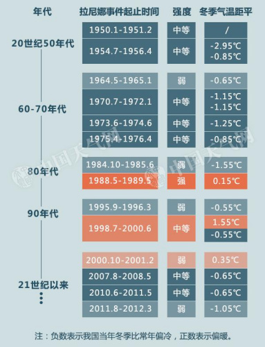
According to China Weather Network, one of the impacts of La Nina event on China’s climate is that the temperature may be low in winter, which is prone to cold winter. Statistics show that since 1954, in the years affected by La Ni? a event, the proportion of cold winter in China has exceeded 80%.
For example, in the years affected by La Nina, the winter of 1954 was the coldest one, and the temperature was 2.95℃ lower than normal.
For another example, in early 2008, the La Nina incident was one of the important behind-the-scenes "pushers" of the once-in-50-year freezing rain and snow disaster in southern China.
According to regional statistics, in La Nina, the proportion of cold in winter in Tibet was the lowest, at 50%. In the northwest, southwest, south China and south China, it is as high as 80% or more.
Will La Nina definitely lead to a cold winter?
Will La Nina definitely lead to a cold winter? Li Xiaoquan said that normally, when La Nina happens, China will be colder in winter, but it doesn’t mean that it will enter the cold winter, but the probability of entering the cold winter is higher, especially in the southern region.
"La Nina came last year, which will make winter cold, but it doesn’t mean it will be particularly cold. It can be seen that some years have entered the cold winter, which is mostly related to the La Nina phenomenon, but it is not La Nina that will definitely enter the cold winter. "
As it said, it was also the winter of 1998/99 when the super El Ni? o turned to La Ni? a, but China experienced a warm winter.
China Weather Network reported on September 22nd that the equatorial Middle East and Pacific Ocean has entered La Nina state, but it has not reached the standard of La Nina event. China Meteorological Bureau will continuously monitor the development of La Nina.